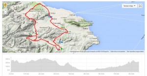
 Benissa – Parcent – Murla – Pego – Gata – Benissa a great trip during Road biking Spain
Road biking Spain; To limit the elevation, this ride is started down in the town of Benissa. This scenic route crosses several valleys and a ‘Parque Natural’ and is 52 miles long. In this ‘flat’ stage there are still around 0.75 miles of elevation gained. At the south side of the village of Benissa the road towards toward Xaló / Jalón is taken. In this descent high speeds can be reached due to its smooth bending curves and the great quality of the asphalt. Arriving in Xaló the direction of Alcalalí is taken and then signs to Parcent are followed. The road to Parcent gradually slopes upward.
Road biking Spain; In this ride we drove through Murla to Benigembla (see map), however, it is better to do it the other way around, so no stretch is ridden twice. Keep following the CV-720 towards Benigembla, then the CV-719 towards Murla. These are two picturesque villages, and later in this ride there are still a number of others passed. Along this route there are many plantations of citrus trees. After Murla a left is taken onto the CV-715, this road ultimately leads to the town of Pego. The section from Sagra is especially magnificent; on either side there are rocks and the road ascends here for about 1.8 miles before the descent towards sea level starts. In Pego the direction of the Mediterranean is taken, this means a right turn here. This road, the CV-678, crosses the Parque Natural Marjal de Pego-Oliva. This reserve is a swamp area with loads of water and thus is home to many aquatic plants and waterbirds.
Road biking Spain; At the end of the CV-678 a right turn is taken onto the N-332 main road which is followed for about 5.2 miles until the exit of the CV-731. The N-332 is a road where cars reach speeds up to 60 miles an hour. But due to the fact that there is a very wide hard shoulder one can cycle safely over here. In the village of Beniarbeig we turn left onto the CV-732 towards Dénia. The road goes up again gradually and after Pedreguer the direction of Gata de Gorgos is followed. Again through the N-332 Gata is reached, after about 100 yards a right turn is taken at the sign indicating Xaló / Jalon. This is the CV-748 through the valley of Llíber. From the tunnel under the AP-7 this stretch towards the highest top over Llíber is 4.3 miles long with 150 yards of climbing. A gradual climb, with the right side of the dry river bed of the Rio Gorgos Xaló; a beautiful part of Spain!
Here a link to the town of Llíber, the area of Marnes belongs to this municipality. In Llíber direction Senija is followed, where the last stretch of climbing has to be done before descending towards Benissa.
This is a a wonderful stage through the beautiful landscape of the Costa Blanca region during road biking spain


