 Top of Montgó is a hike you have to do if you are on hiking holidays alicante
This beautiful hike to the summit of the Montgó is about 9.3 miles long. Due to the altitude difference, and much clambering, this is a hike of a high degree of difficulty. For this trip, it is wise to leave in the morning so you have enough time as it takes about three hours to get to the top and about three hours back.
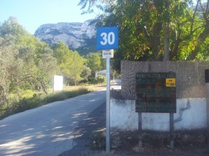
 Hiking holidays Alicante; From Refugio Marnes to the starting point of the walk it is an hours drive. Drive on the N-332 towards Valencia and take the exit to Dénia. In Dénia there are signs that show the direction to Parque Natural del Montgo and eventually two signs will appear for ‘Centro de Intrepetación’ and to ‘Rutas y Senderos’ or ‘Ermita Pare Pere’, the latter two are followed. The car can be parked at the sign (see photo), or you can chose to drive a bit more uphill. The hike described below is done from this particular sign.
Hiking holidays alicante is a great idea all year trough
The first part runs for 0.6 mile on a paved road up to an iron chain which marks the beginning of the park. Here the car can be parked as well. Once stepping over the chain an ascending, winding path leads uphill. After 0.4 miles you can make a choice at this sign (see photo). You can either go to Cova Camell, an overhanging rock where you have beautiful views of the coastline. For this walk the path on the right should be chosen. Or for Cim Montgo, meaning the top of the Montgo an easily accessible road is followed for about a 0.6 mile before turning left for a narrow ascending path entering a dense forest.
Hiking holidays Alicante; From this point the next mile goes uphill with the last 0.3 mile being really steep. Two handy tips to keep in mind during this route are the following. Firstly, the path may at times seem very steep, and because the stones are coloured brown they give the impression that this way is widely used. You may find yourself clambering the road to proceed here so look around at such times because there is almost always a short cut off the official path which is easier to navigate. Secondly, occasionally other paths join the path you are on and can cause confusion on which route to follow. Keep in mind that this path leads to the top so your choice of path goes up, bearing this in mind you will not go wrong.
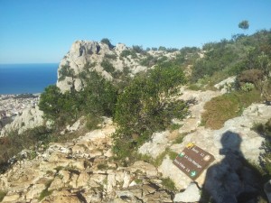
 When you have overcome the tough part of the climb, the following sign on a stone appears (see photo). This show that it is 3.4 km (2.1 mile) to the top and this last part ascends gradually so this is not as difficult. Finally, a pole indicating the top of the Montgo at 753 meters above sea level is reached, and beautiful views can be enjoyed. Really a hike you can´t miss on hiking holidays Alicante. If you want to read a general page about hiking holidays Alicante click here
You can find this hike on Wikiloc but it is not the complete walk, I started too late in the afternoon 🙁


